
Land
Using an integrated geoscience approach to characterise your site
Land Solutions
Using an array of in-house geoscience and survey technologies and expertise to provide accurate and rapid characterisation of sites, structures and buildings.
Geophysical Survey
Geo-4D can acquire, process and interpret a variety of geophysical datasets to investigate and quantify the properties of the subsurface.
- Magnetic anomaly/UXO detection
- Utility mapping
- Void detection
- Geological mapping
Shallow Geotechnical Investigation
Geo-4D use a pneumatic dynamic probe and manual dynamic cone penetrometer to characterise shallow geotechnical conditions.
- Shallow foundation design
- Cable burial assessment/routing
- Sediment thickness mapping
Topographical & Building Survey
Using a combination of laser scanners, total stations, GPS and drones, Geo-4D can produce accurate and resolute 3D models of structures and sites, from which to produce survey deliverables.
- Topographical drawings
- Elevations
- 3D models
- Floor plans
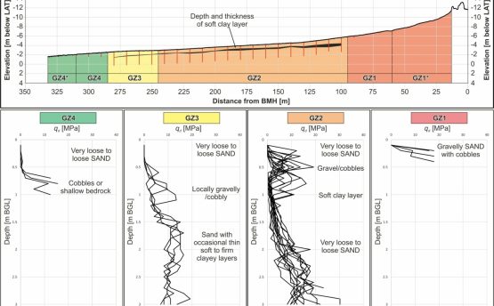
Desk Studies and Ground Modelling
Using a variety of modeling software and available public and site-specific data, our geoscientists can produce comprehensive desk-based studies detailing ground conditions, hazards, and uncertainties/data gaps for geologically complex sites.
Request a call back with us, and we will do the rest
Interested in what we do? Need more information.
Geoconsulting, remote sensing
and survey experts
Links
Receive a call back.

Get in touch with us
Navigation
Useful Information